-- Article list --
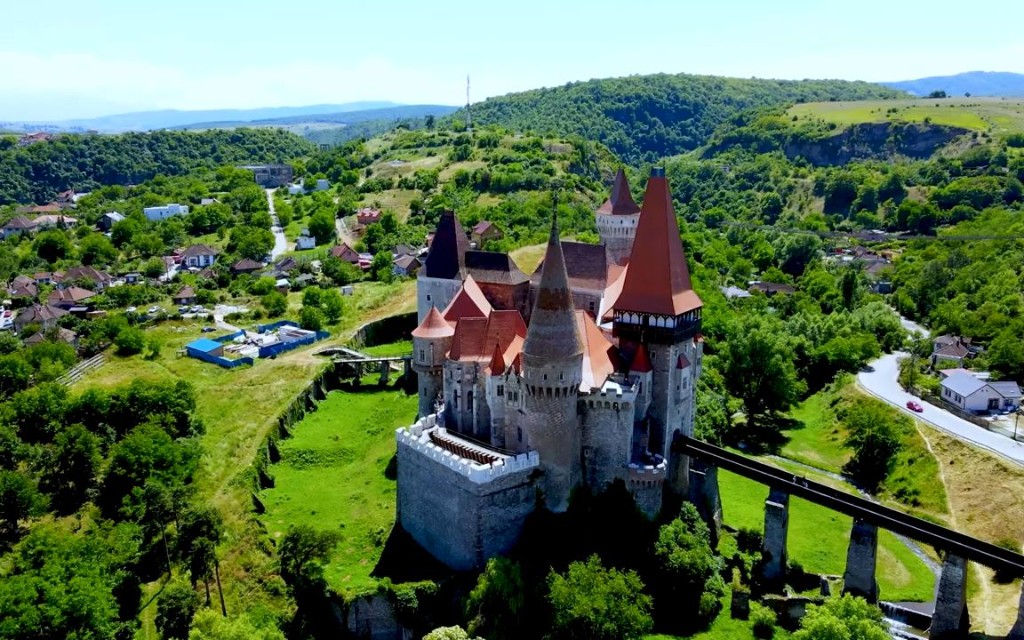
Most travellers racing between Bucharest and the Black Sea coast treat Călărași as a dot on the map—a place you pass through on the A2 motorway or a DN road, maybe stopping for fuel and a coffee. That's the irony: you have to slow down to realise the city isn't trying to compete with the usual Romanian hits. It doesn't have a Bran Castle or a painted monastery. What it doeshave is the Danube itself—wide, restless, border-making—and a particular kind of lowland honesty that rewards anyone willing to linger by the water.
The city's name tells you where to look. Călărași comes from călăraș—a mounted courier or horseman—because this place began as a riders' relay station on the old Wallachian route between Bucharest and Constantinople, formalised under the princes in the 17th century and already showing up on maps by 1700. You can still feel that frontier-logic in the layout: the river is the main character, the streets feel like they were drawn to reach the bank quickly, and the city's 19th-century momentum—grain trade downriver, port traffic, eventual county-capital status in 1834—was always about movementrather than monument-building.
So the tourism here is really about river life, open horizons, and a slow provincial dignity that's increasingly rare. The Danube promenade / faleza nordului is the city's living room: an evening place where the air smells of water and sun-baked concrete, where families stroll and the opposite bank—Bulgaria, just across the Borcea—feels close enough to touch. In summer, that riverfront logic spills onto the sand at Plaja Mare and the smaller city beaches, turning Călărași into a low-key, local-kind-of-resort that never tries to be Mamaia and is better for it.
Culturally, the city punches through memory and craft rather than grand squares. The Municipal Museum / Muzeul Dunării de Jos (Lower Danube Museum) gives you the deeper timeline—archaeology from the Danube corridor, everyday objects, ethnographic texture from the plains—reminding you that this stretch of river has been a thoroughfare since antiquity. The Old Water Tower (Turnul de apă, 1900) on Bulevardul 1 Mai still cuts a nostalgic silhouette; climb-aware or not, it anchors the city's early-20th-century modernisation in your mind. And the St. Nicholas Cathedral (Catedrala Sfântul Nicolae), with its Orthodox gravity and prominent dome, quietly frames the centre the way a cathedral should—less as a photo-op, more as a reminder that this is a river city of sailors, traders, and border priests.
What surprises visitors most is how "Danube Delta-ish" the periphery can feel without the crowds. The Borcea branch braids into islands, old channels, reed beds and forested patches—habitats that support birds, fish, and a whole ecosystem of sport-fishing and hunting culture that draws repeat visitors (including Italians, according to local travel write-ups) who come back not for sights but for the river's generosity. If you cross by ferry from the Chiciu / Podul 4 area toward Silistra, the Danube stops being scenery and becomes a border you're physically crossing—an unusual, very real experience for a day-tripper.
Călărași will also be honest with you about its 20th-century layer: the combinat siderurgic era left the city a major steel/industrial footprint, and the post-'89 transition left its scars—but also a certain unpretentious resilience. These days the city is pivoting harder toward services, food processing, and river-based logistics, while marketing its beaches, promenades, and Danube nature as the actual draw. It's nicknamed locally "Capșa a provinciei"—"the Capșa of the provinces"—a little old-world boast about style and sociability, even if the reality is simpler: a coffee, a river view, and time.
Come to Călărași if you want the Danube without the cruise ships. Walk the faleza at golden hour, eat whatever came out of the water that morning, and let the Borcea's slow current do what it's done for centuries—carry stories, not slogans, from one bank to the other.
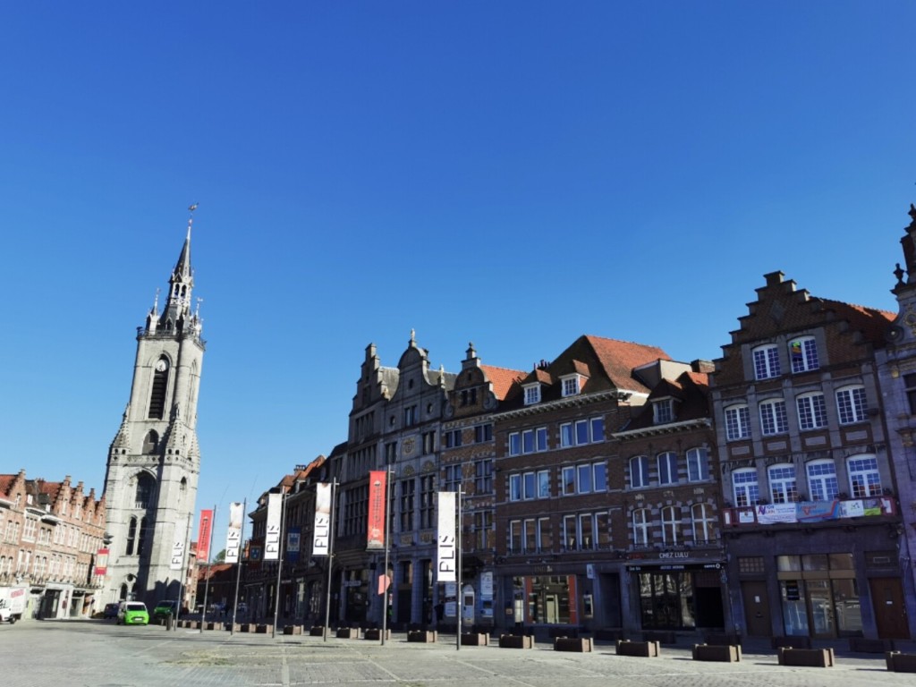
You notice the silhouette before you notice the city. Five heavy, square towers—unexpected, a little stubborn, and unmistakably Tournai—rise above a soft fold of roofs and the slow, grey-green drift of the Scheldt (Escaut). This is the Cité des Cinq Clochers, a nickname the city wears with quiet pride: the towers belong to Notre-Dame Cathedral, whose mass and skyline have been the city’s defining line for the better part of a millennium.
What makes Tournai feel older than most Belgian cities isn’t a plaque—it’s the ground itself. The site began as Turnacum, a Roman administrative and military crossing-point at a key road-river junction; later, it became the kind of place rulers kept close. In the Merovingian era, Tournai mattered enough to be a royal seat—think Childeric I, and the early arc of Clovis’s story—before the political centre eventually slid toward Paris and the city reinvented itself as an episcopal and trading power on the Scheldt. That dual identity—borderland fortress + riverborn merchant-bishopric—still explains the texture of a walk here: stone that feels defensive, but a riverfront that insists on sociability.
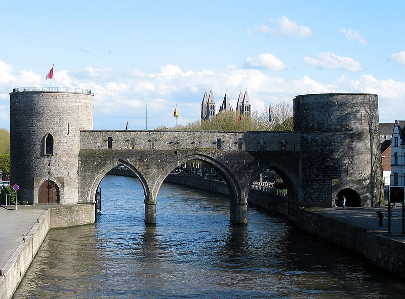
The walk itself tends to start on the Grand Place, where the city’s civic stage is set. Crowning the square is the Belfry (Beffroi)—often described as the oldest belfry in Belgium, a squat, serious, fiercely symbolic tower that once watched for danger and fire, and now mostly watches over café terraces and market-day noise. A short drift downhill or sideways will bring you to the Pont des Trous, the medieval bridge-defence pair with turreted towers straddling the Scheldt—less a photo-op than a reminder that Tournai once had to guardthe very river that fed it.
Then there’s the cathedral itself—Notre-Dame de Tournai—which is less a single “style” than a conversation between centuries. The Romanesque nave and transept belong to the 12th-century vision of a city that wanted to look immovable; the Gothic choir, reshaped under the bishops of the 13th century, opens the interior upward and eastward with a lighter, more vertical ambition that clearly listened to the great cathedrals of northern France. Inside, the eye catches the kind of details that turn a visit into a memory: the Renaissance rood screen in black Tournai marble, the glow of stained glass, the treasury’s liturgical art—objects that explain why this building didn’t just serve a diocese, but helped broadcast the city’s status. (UNESCO lists the cathedral as a World Heritage Site, which is why the “five towers” never feel like mere decoration.)
But Tournai’s cultural gravity also lives in things that aren’t cathedrals. The Museacute;e des Beaux-Arts, designed by Art Nouveau architect Victor Horta, gives the city a very different kind of façade—less fortress, more curatorial light—and houses paintings that span from the medieval to the modern, tying Tournai back into the larger Flemish/Walloon art narrative without ever losing its own accent. Add smaller, quirkier anchors—tapestry heritage, archaeology, natural history—and the city reveals itself as a place that collected objects and storiesthe way a river collects tributaries.
You leave Tournai understanding why locals call it Belgium’s oldest city in spirit if not in trivia-night technicality: it doesn’t perform antiquity; it inhabits it. Come for the five towers and the river light; stay because the Grand Place still knows how to pour a drink and watch the bells; and if you time it right, you’ll realize the best souvenir isn’t a postcard of the skyline—it’s the way the stone here feels like it’s been waiting for you since the road first crossed the Scheldt.
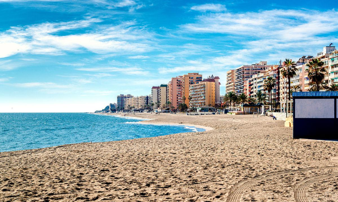
Sun on the Mediterranean does not feel like a promise in Fuengirola so much as a default setting. Set along a narrow, eight-kilometre ribbon of coastline on the Costa del Sol, the town arranges itself around light, salt air, and a long, confident stride of a seafront: the Paseo Marítimo Rey de España, a palm-lined promenade that runs for roughly 7–8 km from the vicinity of Sohail Castle eastward past a succession of well-kept beaches—Los Boliches, Las Gaviotas, Santa Amalia, San Francisco, El Ejido/Playa del Castillo—until the terrain drifts toward Torreblanca/Carvajal. It is the kind of walkway that doubles as a social calendar: morning runners and cyclists, late-afternoon paseo, then the slow golden-hour pause at a chiringuitowhere the grilled-fish smell is basically the town’s signature perfume.
But Fuengirola is not only “sun and sea.” Its floorplan conceals older strata if you know where to look. On a low hill above the river mouth, Castillo de Sohail—with origins traditionally tied to the 10th century and the era of Abd al-Rahman III—still guards the coast with fragmentary walls and a commanding view; today the fortress is less a defensive hinge than a cultural stage, hosting concerts and open-air events against a backdrop of sea and stone. Scattered nearby are reminders that this place has been a landing point and crossroads for a very long time: traces linked to Phoenician presence, the Roman site of Suelon the castle hillside, and Roman baths and villa remains at locations such as Finca del Secretario and Torreblanca, layered quietly beneath a modern, service-rich resort town.
Back down at sea level, the town’s more intimate centre is the human-scale Plaza de la Constitución, where café tables spill into the square and the white façade of the Iglesia de Nuestra Señora del Rosario (Parroquia del Rosario) anchors the old-town rhythm. It is a space made for people-watchingas much as sightseeing—the kind of square where a coffee can easily turn into lunch, and where the Andalusian habit of lingering feels less like a lifestyle choice and more like civic duty. Side streets and pockets such as Santa Fe de los Boliches keep that popular architecture and fishing-quarter memory alive even as the wider strip thrums with hotels, apartments, and a genuinely international everyday life.
What gives Fuengirola its contemporary cultural weight, though, is how it blends a classic resort toolkit with a few unexpected, strongly “curated” experiences. The Bioparc Fuengirola is the clearest example: what began as a rethinking of an older zoo model was transformed from 2001 onward into a “zoo-immersion”—vegetation, water, and sightlines used to dissolve bars and cages so that visitors move through simulated tropical ecosystems (Madagascar, equatorial Africa, Southeast Asia/Pacific islands) rather than past rows of cells. Conservation and education sit at the core—part of the park’s identity as a modern bioparc rather than a spectacle-only zoo—and it has continued to evolve, with recent expansions leaning into reefs, aquatic environments, and narratives tied to exploration and biodiversity.
Then there is the city’s social texture, which may be its most distinctive selling point: Fuengirola lives as an international, highly cosmopolitan community, and it celebrates that identity openly. The best expression is the Feria Internacional de los Países / Feria de los Pueblos (FIP), staged each spring at the Recinto Ferial, where dozens of countries run casetas with food, drink, music, and dance, and the whole town briefly feels like a low-barrier world tour—parade through the streets, rhythms from five continents, and an atmosphere that is as much about coexistence as entertainment. Add the maritime Virgen del Carmen processions in summer and the October Rosario/patron festivities, and you get a resort town that knows how to throw a party andkeep a liturgical calendar.
So Fuengirola reads as a place of contrasts held together by the sea: Phoenician and Roman roots → Moorish fortress → fishing quarter → 20th-century resort growth → today’s multicultural, family-friendly, event-driven Costa del Sol hub. Come for the long beach days and the promenade; stay for the castle-lit evenings, the old-square coffees, and the sense that in this corner of Andalusia, the world has already arrived—and been invited to set the table.
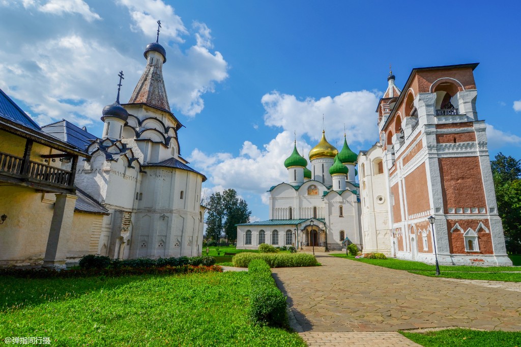
Podolsk rarely tries to impress you at first glance. Forty minutes south of Moscow by train, the city announces itself not with a skyline but with a softer geography: the Pakhra River bending past brick, lime trees, and the long, low rhythm of a Moscow-region town that grew up where a monastery’s riverside settlement once kept watch over trade routes heading southwest out of the capital. What you notice first is the light on the water and the way the city seems content to live beside it rather than rearrange it—an honesty that gives Podolsk its particular appeal as a southern gateway to the Moscow oblast.
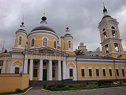
History here has a precise hinge date locals are proud of: Podolsk was granted city status in 1781, under a decree of Catherine II, and you can still feel that late-18th/early-19th-century municipal self-image on Cathedral Square, where the golden domes of Trinity Cathedral (Troitsky Sobor) pull the eye and the pavement seems to remember processions and market days alike. Built in the wake of the 1812 war era and tied in spirit to the generation of architects who reshaped Moscow afterwards, the cathedral anchors the city’s visual identity—classical proportions, a calm verticality, and the sense of a town that wanted to look like a city, even as it kept its riverfront manners.
Walk downhill from that civic core and the Pakhra reappears, its embankments and park strips turning the city into something walkable and quietly romantic. This is where Podolsk works best on a visitor: not as a checklist of monuments, but as a weekend rhythm—slow promenades, river air, the occasional brass band or open-air event drifting out of a park, and cafés that feel made for lingering once the sun lowers over the rooftops.
Layer in the surroundings, and the portrait deepens. Just outside town, the Ivanovskoye estate spreads a classical 18th–19th century ensemble—main house, wings, and parkland—along the river, the sort of place where the idea of “country nobility life” becomes tangible in gravel paths and sightlines rather than plaques. Not far away, the Dubrovitsy estate shifts the mood into something more theatrical: its Church of the Sign (Znamenskaya) is one of those love-it-or-debate-it baroque marvels—Western influences, a soaring crown-like silhouette, and a white-stone precision that makes it feel transported from a different canon altogether. Together, these estates argue that Podolsk’s real tourism asset isn’t a single “wow” building downtown; it’s the scatter of aristocratic architecture across the Pakhra valley, each with its own garden logic and river view.
And then there is the city’s other memory—the industrial one. In the early 20th century, Podolsk became the kind of place where modernity arrived loud and mechanical, most famously in the brick-and-glass footprint of what began as the Singer sewing-machine plant complex and later evolved into Soviet-era machine-building. Today those architectures read as heritage too: big-windowed, rational, slightly austere, and oddly photogenic when the evening light hits the masonry. It’s a reminder that Podolsk’s identity is double-threaded—manor-house poise and factory-floor grit, both braided into the same river corridor.
Come for a morning at the cathedral square; stay for the riverside air and a late lunch somewhere unpretentious; and, if you have a car or a willing local guide, let the afternoon stretch to an estate drive. Podolsk won’t perform like a museum piece—it receives you as a working, commuter-shaped city that happens to keep its best stories along the water and in the courtyards of its past.
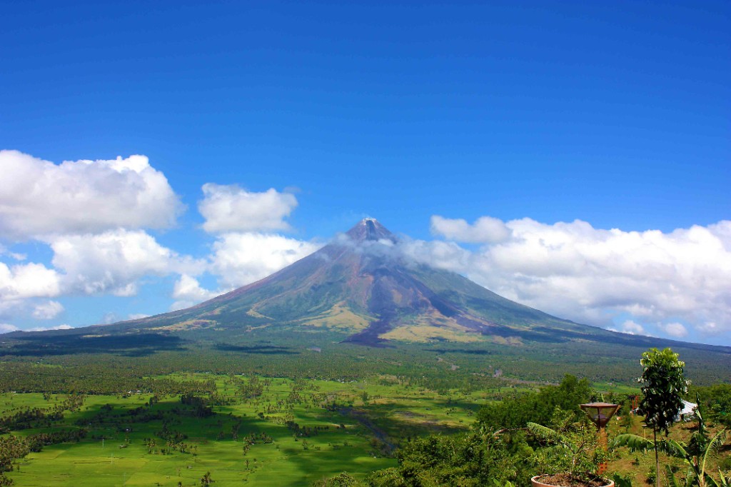
Legazpi doesn't announce itself with a skyline so much as with a silhouette. On clear mornings, the cone of Mayon Volcano—symmetrical, restless, and almost absurdly perfect—rises above the roofs and palms like a sentence the landscape refuses to finish. Tucked into the curve of the Albay Gulf in the Philippines' Bicol Region, Legazpi is the provincial capital that lives comfortably in the shadow of an active stratovolcano, and somehow that tension is exactly what makes the city feel alive.
The city is really two moods stitched together. One belongs to the seafront and the old port: a warm, salt-air rhythm of fishing boats, breezy promenades such as Legazpi Boulevard, and the casual evening theatre of sunset over water, with Mayon's outline sharpening as the light drops. The other mood belongs to the old Albay district and its heritage spine, where church façades, plazas, and civic buildings recall a long layering of local faith and colonial history—most iconically expressed just outside town at the Cagsawa Ruins, where a lone bell tower stands in open fields as a stark, photogenic memorial to the 1814 eruption and to the resilience that rebuilt around it.
Between those poles, Legazpi offers the kind of tourism that is equal parts scenery and sensation. You can take the short climb up Ligñon (Lignon) Hill for the classic panoramic frame—volcano, rooftops, gulf, and all—or head to hilltop vantage points like Daraga Church where the view makes the descent feel optional. Then there's the ground-level Bicol experience: coconut-rich, chili-bright cooking (Bicol Express, laing, pili-nut snacks) that turns a simple meal into a reason to linger, and a street-and-seafood culture that feels generous without trying too hard.
If Mayon is the headline, the supporting act is Legazpi's role as a gateway: arrivals typically flow in through what's still colloquially called Legazpi Airport—the newer Bicol International Airport in nearby Daraga—which keeps the city connected to Manila and the rest of the country even as it keeps its own tempo: slow enough to watch clouds lift off a volcano, fast enough to remind you that the earth here is still awake.
In the soft, humid heart of Côte d’Ivoire, where the forested inland plateaus loosen into savannah and the roads begin to smell of red earth and diesel, Yamoussoukro insists on being unlike anywhere else in the country. It is the political / administrative capital—the city where the state’s symbols are planted—while the country’s economic pulse still lives closer to the sea in Abidjan. That dual-centre arrangement gives Yamoussoukro a strange, beautiful calm: it feels less like a crowded megacity, more like a capital that chose space over density, and then tried to fill that space with monuments, boulevards, and silence.
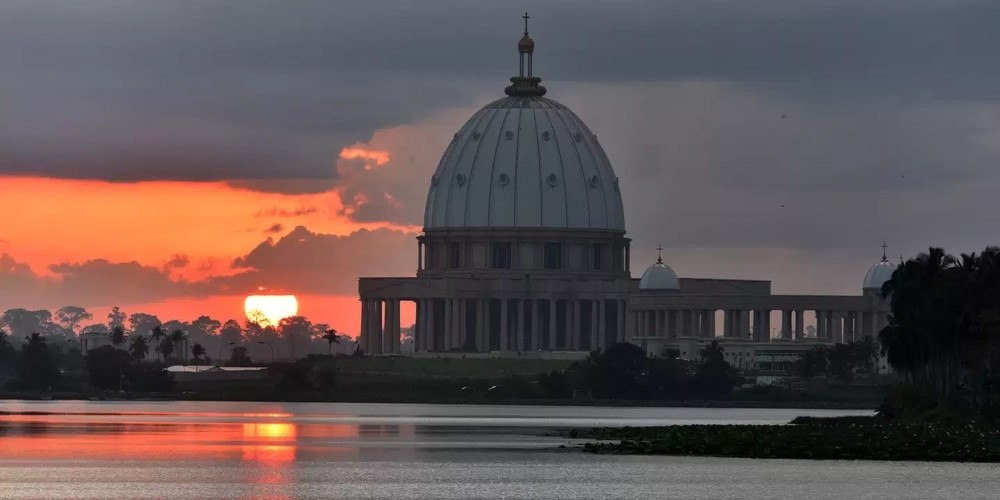
The image most travelers carry here is inevitable: the Basilica of Our Lady of Peace (Basilique Notre-Dame de la Paix), its pale dome and colonnades rising above trimmed gardens as if a slice of Rome had been lifted and set down in the tropics. Built between the mid-1980s and 1989, consecrated in 1990, the basilica is huge in scale, lavish in material, and unapologetically photogenic; whether you come as pilgrim, architecture buff, or curious visitor, the effect is less about doctrine and more about the theater of light on marble and stained glass, and the surreal contrast between that gleaming ensemble and the quiet, sun-baked avenues around it.
But Yamoussoukro’s real charm is how quickly the “capital” mood slips into something earthier. Turn away from the grand axis and the city reveals itself as a working inland hub—neighbourhood markets where Baoulé and Dioula rhythms of trade never really stop; roadside chop bars bright with attiéké and grilled fish; and long, straight roads that seem to end in heat haze rather than rush hour. It is a place where the state is present, but nature and rural life are never far: you can step out of the ceremonial core and into mango shade, then keep going into the wider Lacs district countryside, where rivers, reservoirs, and scattered villages set the tempo instead of traffic lights.
For the culturally curious, Yamoussoukro works best as a gateway rather than a checklist. Within reasonable reach lie experiences that explain why this region feels like the country’s interior soul: the vast shimmer of the Kossou Lake / Kossou Dam area to the south, where fishing canoes dot a reservoir that rewrote local geographies; and, a little farther afield, managed bush country such as the Abokouamékro Wildlife Reserve, where guided drives trade the capital’s formalism for dust, scrub, and the slower thrill of wildlife seen in the open. Meanwhile, the city’s own cultural layering shows up in small, human ways—cloth markets, roadside weavers, and the occasional ceremonial drumming that reminds you this is Baoulé country as much as it is a seat of government.
Come for the basilica’s spectacle; stay for the inland atmosphere that refuses to be glossy. Yamoussoukro doesn’t perform for tourists—it receives them, with wide streets, heavy heat, and the sense that you’ve stepped off the coastal script and into the part of Côte d’Ivoire where the land still decides the pace.
Brovary is a city in Kiev Oblast province in northern Ukraine, an eastern suburb of the country's capital, Kiev. Administratively, it is incorporated as a town of oblast significance. It also serves as the administrative centre of Brovary Raion (district), though it does not belong to the raion. The Population of Brovary is about 98,250 in 2013.
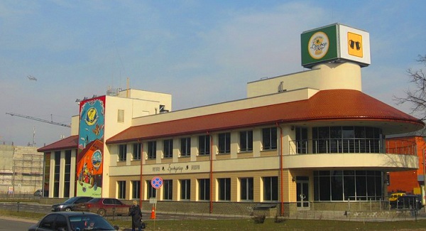
Brovary is a historic town, first mentioned in 1630. Its name, translated from Ukrainian, means "brewers". The city also houses a railway station. International ill-fame came to the city in 2000 after one of itsapartment blocks was hit by a stray surface-to-surface missile launched from a neighbouring army shooting range in Honcharivs'ke. Three people were killed.
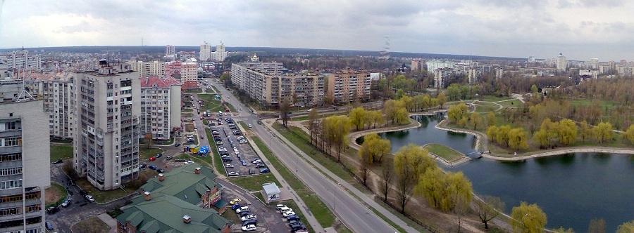
Today, Brovary is Ukraine's shoe-making capital with dozens of such companies located here. At Brovary, there is also a broadcasting centre for long and shortwaves. The longwave transmitter, which works on 207 kHz, uses as its antenna two 259.6 m (852 ft) tall guyed mast radiators each equipped with a cage antenna at their lower part. Brovary is also an important sport centre of Ukraine. Several world and Olympicchampions were born and/or began their career here. Ukraine's national mint facility is located in Brovary.
Brovary is a district centre in Kyiv region. It is situated 20 kilometers from the capital of Ukraine, Kyiv. Brovary district lies in the areas of mixed forests. The climate here is moderately continental with the middle temperature -6 C in January and +19 C in July.
The territory of the region was populated ages ago by the ancestors of the current inhabitants � trypillians, who were the first in Europe to sow seeds of the well-known Ukrainian bread.[citation needed]Brovary was firstly mentioned in 1630. In that time there were only 60 or 70 houses in Brovary, but in 1649 a Cossack sotnya is known to have been formed there. Cossacks took part in Liberation movement under Bohdan Khmelnytsky`s leadership.
International ill-fame came to the city in 2000 after one of its apartment blocks was hit by a stray surface-to-surface missile launched from a neighboring army shooting range in Honcharivs`ke. Three people were killed.
Brovary was twinned with Hengyang City in November 1995.
Relevant links:
http://en.wikipedia.org/wiki/Brovary
http://brovary-city.in.ua/map/
|
Overseas sister city
|
Country
|
Continent
|
Date to be twined
|
|
Ritto City
|
Japan
|
Asia
|
1992-10-07
|
|
Podolsk
|
Russia
|
Europe
|
1993-09-20
|
|
Tournai
|
Belgium
|
Europe
|
1994-12-10
|
|
Brovary
|
Ukraine
|
Europe
|
1995-11-14
|
|
Fuengirola
|
Spain
|
Europe
|
1999-09-24
|
|
Calarasi
|
Romania
|
Europe
|
2002-10-15
|
1. Ritto City